Looking for a location within Turkey? You can find it with this interactive Google map.
Instructions on how to use the map of Turkey
- Use the + and – markers on the left-hand side to zoom in and out
- Use the direction wheel on the top left-hand side to move from one location to another. Alternatively, hold the map with your mouse and move to the location that you want to see in-depth
- To print out the map, a specific area in Turkey or instructions on how to get there, look outside of the map to the left-hand side. There is a print button; press that and follow the instructions
- If you would like to search for a specific destination in Turkey, press “View Larger Map” in the right-hand corner under the map. This will then take you to Google
Map of Turkey showing the 81 provinces
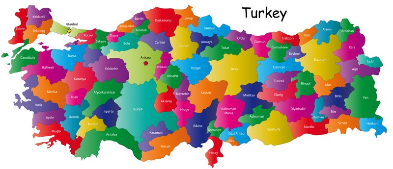
Geographical Facts of Turkey
Geographical Facts for a Map of Turkey
1 The capital of Turkey is Ankara
2 Turkey spans over 770,760 square miles and is the world’s 37th largest country
3 Turkey borders eight countries, including Bulgaria, Greece, Georgia, Armenia, Azerbaijan, Iraq, Iran, and Syria.
4 97% of Turkey is in Asia minor while 3% is in Europe.
5 The three largest cities in Turkey are Istanbul, Ankara, and Izmir
6 Within seven regions are 81 official provinces.
7 Turkey separates into seven regions which each have their climate…
Marmara: Aptly named because it sits next to the Marmara Sea in Northwest Turkey, the Marmara region includes famous Istanbul, the hub of Turkish business, economy, finance, education, and tourism. While most of Marmara belongs to Asia, a small part is in Europe.
Black Sea: On a map, the Black Sea refers to the whole Northern Coast. This region includes famous places like Trabzon and Rize in the Northeast. It is also renowned for plateau tourism. The region is culturally diverse and has beautiful landscapes views that are quite different from the rest of the country. Without a doubt, it is one of the most under-rated places in the country.
Central Anatolia: Sitting in the heart of Turkey, famous places here include the Cappadocia region, Konya city and the Capital of Turkey, Ankara city.
Eastern Anatolia: Covering the landlocked eastern borders of Turkey, the Eastern Anatolian region includes famous cities like Van and Kars. Fewer tourists and expats head here because of the lack of beaches and a more conservative lifestyle.
Southeastern Anatolia: Three famous places here include Old Mardin, Gaziantep, and Sanliurfa. For many years, tourists avoided the area because of its border with Syria but are now returning.
Aegean: Covering the western coast on a map, the Aegean is a famous tourist region thanks to places like the Bodrum peninsula. It is also possible to island-hop over to the Greek Islands. Main airports include Bodrum and Izmir.
Mediterranean: The most popular place for beach tourism thanks to the ideal weather climate. On a map of Turkey, the Mediterranean refers to the long southern coastline. Hubs include Fethiye, Marmaris and Antalya. The airports used are Dalaman and Antalya.
For more information and posts about Turkey, please see the homepage.